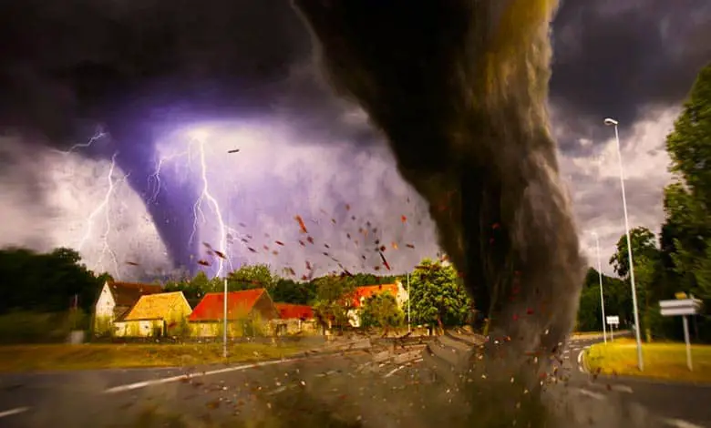
Hello, adventurers of the atmospheric wonders! Have you ever watched the sky darken and felt the electric tension in the air, signaling the approach of one of nature’s most fascinating and fearsome phenomena—a tornado? These swirling wind vortexes hold power and mystery that have captivated humans for centuries. But what exactly triggers the birth of a tornado, setting the stage for its awe-inspiring dance across the land?
Tornadoes are one of the most feared and destructive forces on the planet, capable of producing catastrophic damage. That trail of destruction is used to determine the tornado’s rating. It’s called the Fujita scale or EF scale. Tornadoes occur on every continent except Antarctica but form more in the central United States than in Tornado Alley. That’s because conditions in the Alley are ideal for creating tornadoes.
Warm, humid air below the ground moves north from the Gulf of Mexico and collides with cool, dry air high above the ground, rolling in from the Rocky Mountains. The collision of air masses creates a supercell, a massive thunderstorm with a strong rotating updraft.
Scientists aren’t exactly sure what happens next, but the leading idea goes like this: The difference in speed between the faster high winds and the slower low winds causes the air in between to rotate around the horizontal axis. If one end of the rolling stand gets caught, the updraft is bent upward, forming a funnel cloud. Its spin gets tighter and faster, and the cloud gets longer. Rain or hail from the thunderstorm can then push down on the funnel cloud’s tail until it reaches the ground, forming a tornado.
Most tornadoes’ top wind speed is usually under 110 miles an hour, and most touch the ground for less than ten minutes. However, extreme tornadoes are genuinely extreme. The Tri-State tornado cut the longest tornado path on March 18, 1925. It tore up property for 219 miles.
We’re going to whirl into the heart of the storm to uncover the secrets behind the formation of tornadoes. From the clash of weather fronts to the intricate dance of air masses, we’re exploring the conditions that spawn these incredible forces of nature. Are you ready to twist through the science of tornadoes? Let’s get swept away in discovery!
What is Tornado?
A tornado is a fast-spinning column of air stretching from a thunderstorm cloud in the sky to the Earth’s surface. They form inside massive thunderstorms. The cold, dry air moves from one direction and bumps into warm, wet air from a different direction. The cold air is heavier. It slides down under the warm air and pushes it up fast. All this fast-moving air rushing up and down can create a spinning thunderstorm, and it can eventually keep going to form a tornado.
It can be one of the most powerful forces. In nature, tornados and winds are the strongest globally, even stronger than hurricanes. The wind can blow almost 500 kilometers an hour, strong enough to lift heavy things like cars and trucks into the air. Usually, tornadoes travel across the land at about 50 kilometers an hour, slower than most cars.
What causes a Tornado to form?
Tornadoes are also known as twisters or cyclones. The swirling, funnel-shaped winds are easily recognizable and can be very dangerous. But what causes these unique and violent weather phenomena? Tornados usually begin with a thunderstorm. But not only any thunderstorm but a specific rotating thunderstorm is also called a supercell. They can bring damaging hail, strong winds, lightning, and flash floods.
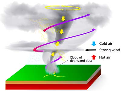
Supercells form when the air becomes unstable, and wind speed and direction differ at different altitudes. This condition is called wind shear. Wind shear is common in the formation of most thunderstorms. But when the ground-level wind blows in one direction, the higher up in the atmosphere blows differently.
It can cause a horizontal tube of air to form. In a thunderstorm, warm air rises within the storm. This is called an updraft. An updraft can turn a horizontal rotating air tube into a vertical one. When this happens, the whole storm begins rotating, creating a supercell. Some supercells form a funnel cloud. If that funnel cloud extends to the ground, it is a tornado.
Tornados can produce winds up to 300 miles per hour at the surface, making them dangerous to people and property. As a tornado moves along the ground, its strong winds pick up debris. Flying debris causes the most damage in a storm. Meteorologists are keeping an eye on your local weather. They will try to warn you if a tornado will likely form in your area.
Scientific explanation: Tornadoes are rotating columns of air in contact with the earth’s surface and a cloud. A strong wind blows through the clouds and twists the rising air currents into a whirlwind. The warm air flows upwards, and a downward air current forms, creating a thunderstorm. Strong twisting winds and warm air combine to make a tornado. Tornadoes damage almost anything that comes in their path.
- Tornadoes move at speeds of up to 100 kilometers/hour.
Cold, dry air comes from the West, and warm, moist air comes from the south. The combination of these causes the air to rotate in the mid-levels. Eventually, what will happen? This rotating air will turn from a horizontal to a vertical direction within the thunderstorm. It is called the updraft of a thunderstorm.
The updraft within the storm rotates over time. It rotates faster and faster. It creates a lowering or a rain-free area called the wall cloud. From that wall, the cloud descends the actual funnel itself. Once that funnel touches the ground, a tornado will form.
If the storm pattern remains, random and disorganized scattered storminess will be the only result. But if the storm pattern is more organized and rising warm air becomes cool, the clouds begin to swirl. More warm air is sucked up from the ground a funnel cloud begins to take shape. If it touches the ground, it’s a full-on tornado.
Sign of tornado: It’s tough to predict precisely when and where it will strike.
- However, dark greenish skies, rotating clouds, and hail are good signs.
Supercell’s tenacious and long-lasting storms create the most powerful tornadoes. The emergency broadcast system may issue a tornado watch indicating that conditions are ripe for tornado weather or a warning. In the northern hemisphere, a tornado spins counterclockwise. In the southern hemisphere, tornadoes rotate clockwise. Meteorologists spent a lot of time studying them. They want to understand more about exactly how and when tornadoes can form.
What causes a fire tornado?
The updraft is simply a rising current of air. In this case, it is generated by the heat of the fire. Hot air rises and puts a huge amount of heat into the atmosphere. The fire and all of that air are going to accelerate upward. So that’s the primary updraft driven by the fire. When air flows up, it also necessitates air to flow in.
All of the air going up has to be replaced from somewhere. Also, it’s going to draw air in from the sides. We might call an inflow jet or a fire-induced wind a horizontal wind. Also, it essentially converges from all directions into the location of the updraft. Fire is the wind shear in the environment, air flowing in different directions adjacent to the other air stream.
People often confuse what we consider a fire tornado with a fire whirl. Meteorologists exactly agree on what distinguishes between fire whirls and fire tornadoes. Fire tornadoes and fire whirls start with strong updrafts from the fire and strong inflows related to the fire itself. But fire tornadoes get even bigger because the fire initiates its weather system to concentrate the rotation in the lower atmosphere.
Fire tornadoes develop a link to what’s called an overlying pyrocumulonimbus cloud. It is a fancy word for fire-generated thunderstorms. The column of hot air rising from the wildfire can trigger its weather system and thunderstorms.
As the plume gets higher and higher in the atmosphere, it eventually reaches a point where it’s cold enough. It can no longer hold the initial amount of water. It forces water from the invisible phase into a liquid cloud droplet, and a bright white cloud develops in the plume. Some of that water must be forced into a cloud droplet every time. It uploads some heat back into the atmosphere. Latent heat is released when water changes phase from invisible water vapor into visible white cloud droplets.
It releases some heat during that process, and when millions of droplets do that, it is tremendous. The fire is driving this big column of air going up. It gets deep enough, and then it starts adding heat back into the column.
What country has the most tornadoes?
Tornadoes are far more common in the US than anywhere else. For perspective, Europe records around 300 tornadoes per year, whereas the US records well over a thousand. Most of the world’s tornadoes are in an area called Tornado Alley. Tornado Alley has no “official” boundaries, but it’s typically considered an area that extends from northern Texas through Oklahoma, Kansas, Nebraska, Colorado, and South Dakota.
The United States isn’t the only place that gets tornadoes. Southeastern Brazil and northeastern Argentina have some of the same ingredients. Tornado Alley cools mountain air over the Andes and warm, moist air from the Amazon. But even still, the frequency of tornadoes is scoring behind the US. While the right conditions come together, sometimes the geography isn’t exactly correct.
In South America, the Andes aren’t as wide as the Rockies, and the Amazon isn’t as good of a moisture source as the Gulf of Mexico is because of its land. It’s a Goldilocks problem and a delicate recipe. Most people will go their entire lives without seeing a tornado. Some would consider that lucky.
Some people extend it even further east. While most states in the US have recorded at least one tornado, this area is a hotbed, and the main reason for that is geography. The US’s central part is unique because of this vast warm water area. The wide high mountain range extends a long way from north to south.
Harold Brooks is a senior research scientist at the National Severe Storms Laboratory. He used to chase tornadoes now. He studies them from Norman, Oklahoma, in the heart of Tornado Alley. A tornado requires several unique ingredients that Tornado Alley is full of. In Tornado Alley, warm, moist air flows into the plains from the Gulf of Mexico, and cool, dry air flows from over the Rocky Mountains here in the West.
Eventually, a change in temperature or pressure will arrive and lift that warm air into the cool air, forming an updraft. Once these two meet, the warm air’s moisture condenses, forming clouds and thunderstorms.
Under normal conditions, rain would fall from these clouds and cool the warm air, breaking the storm. A strong air current flows west to east in a tornado alley, known as the jet stream. This, paired with the cool mountain air, blows the rain away, keeping the air in the updraft warm and wet. It intensifies the storm and brings us to step two: getting the storm to rotate.
The air coming from the Gulf moves slowly into the plains. Meanwhile, the jet stream from the mountains provides a steady stream of fast-moving high air flowing east. Because the jet stream is flowing faster and in a different direction, it causes the Gulf to rotate like a spinning football below.
When the spinning air gets pulled into the updraft, it’s tilted but continues to spin, causing the entire updraft to rotate. Storms like this are known as “supercells,” creating prime conditions for tornadoes. As the supercell grows, the spiraling updraft stretches toward the ground and forcefully pulls air into the cyclone. Air rushes in from the sides, and a spinning dust cloud forms below, which brings us to the final stage, getting the vertically spinning air to the ground.
What to do during a tornado? (Safety)
An underground basement or storm shelter is the safest place, but you may not have time to reach one. In this case, you must improvise and find the safest position possible. If you are at home when the storms hit, here is some advice:
- If you have a cellar, storm shelter, safe room, or basement available, go immediately to that area. If none of these options are available, you should get to the lowest level of your home.
- Find the nearest windowless interior room, such as a bathroom, closet, or inner hallway.
- Stay as far from the windows as possible. They will shatter when the storm hits.
- Go to the center of the room corners tend to attract debris.
- Get under a sturdy piece of furniture, heavy table, or desk, and hold on to it. Or a mattress, if one is available.
- Protect your head and neck with a blanket, if possible.
That’s the advice if you live in a brick-and-mortar house, but what if you live in a mobile home? Mobile homes are particularly vulnerable to tornadoes. Even if anchored down, the strong swirling winds can still easily overturn them.
When a tornado is approaching, evacuate the house immediately if you are in a mobile home.
- Find the nearest building with a strong foundation and take shelter there.
- If a shelter is unavailable, lie in a ditch or low-lying area safe from the mobile home.
- Use your arms to protect your head and neck.
- Stay alert to the potential for flooding.
If you are at work or school:
- Go to the basement or an inside hallway at the lowest level.
- Avoid places with wide-span roofs, such as auditoriums, cafeterias, gymnasiums, large hallways, or shopping malls.
- Get under a sturdy piece of furniture such as a desk or heavy table.
- Use your arms to protect your head and neck. If you are in a vehicle, never try to outrun a tornado.
Tornadoes can change direction quickly, and a car is no match for the strong tornado gusts and can be tossed through the air. Get out of the vehicle immediately and take shelter in a nearby building. If there is no time to take shelter, use the same advice when stranded outside: lie in a ditch or low-lying area, use your arms to protect your head and neck, and stay alert to the potential for flooding.
Those are a few suggestions for protecting yourself if a tornado hits, but it’s also sensible to be as prepared as possible. According to the Centers for Disease Control and Prevention, CDC, the best way to stay safe during a tornado is to have the following items on hand: Fresh batteries and a battery-operated TV, radio, or internet-enabled device to listen to the latest emergency weather information.
- A tornado emergency plan includes access to a “safe shelter” for yourself and people with special needs.
An emergency kit includes water, non-perishable food, medication, and important information, including telephone numbers.
According to the National Oceanic and Atmospheric Agency (NOAA), no safety is guaranteed during a tornado. Even the possibility of a tornado must be taken seriously.
We’ve twirled through the conditions that converge to create a tornado, unraveling the mysteries of their formation and gaining a deeper understanding of their power. This journey not only quenches our thirst for knowledge but also reminds us of the importance of preparedness and respect for the forces of nature. We hope you’ve enjoyed this whirlwind adventure as much as we have and that it inspires you to continue exploring the wonders and workings of the world around us.
The more we learn about phenomena like tornadoes, the better prepared we can be when nature shows its strength. Until our next adventure into the marvels of the natural world, stay curious, stay safe, and always keep an eye on the horizon for the next discovery. Happy exploring, fellow adventurers of the unknown!
More Articles:
What Is A Dust Storm And Causes
What Is Lake Effect Snow With Facts
How Does A Thunderstorm Form And Structure
What Causes A Hurricane To Form?
References:
Garrison, Tom. Essentials of Oceanography.
Wurman, Joshua. “Doppler on Wheels.” Center for Severe Weather Research.
“Hallam Nebraska Tornado”. National Weather Service. National Oceanic and Atmospheric Administration.
Roger Edwards. “The Online Tornado FAQ.” Storm Prediction Center. National Oceanic and Atmospheric Administration.
Table of Contents