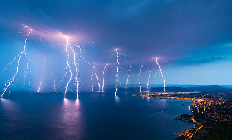
Hey there, storm chasers and weather wonderers! Have you ever found yourself mesmerized by the power and beauty of a thunderstorm, with its dramatic lightning strikes and the rumble of thunder that follows? It’s like nature’s very own theater, isn’t it?
Water evaporates from the surface of the earth. Warm air saturated with water vapor rises. As this happens, the air cools because the higher we get above the ground, the colder it becomes. It is noticeable when you look at mountains. Their peaks are snow-covered, while the areas at the foot of the mountain are still warm. The water vapor turns into a fog with tiny water droplets at a higher altitude. Now, clouds of different shapes are formed from the fog.
For a thunderstorm to appear, the electric charge should be separated. Large and heavy cloud particles usually have a negative charge. Also, Large and heavy cloud particles fall faster. The charge in the cloud separates, creating an electric voltage. It causes lightning. It is an electrical discharge, more precisely, an electric spark of enormous size.
We’re pulling back the curtain on this spectacular show. Grab your raincoat and join us as we go on an electrifying journey to uncover the secrets behind the formation of thunderstorms. From the warm, moist air that fuels their fury to the clash of atmospheric titans that lights up the sky, we’re diving headfirst into the heart of the storm. So, let’s get ready to explore the fascinating science that brings these awe-inspiring phenomena to life!
What Is A Thunderstorm?
Thunderstorms are one of those phenomena caused essentially by differences in temperature, pressure, and so on. The bigger the differences there are, the more severe those thunderstorms are. A big gradient temperature causes winds and the movement of air masses.
Thunderstorms come in a variety of shapes and sizes. They can look like big clumps of cauliflower as they run out of moisture before reaching the top of the troposphere. Also, They tend to spread outward if they reach the stratosphere, forming that characteristic flat and Ville-shaped top of a cumulonimbus cloud. They can occur individually, cluster, or form squall lines that have given enough heat and humidity. Also, they can grow into immense rotating supercells. Then there are the notorious mesoscale convective complexes.
Squall lines that can form one day persist late into the night with heavy rain, hail, and possibly tornadoes before dying by morning. Then, it kicks up again into another line of powerful thunderstorms by afternoon. Larger thunderstorms can even produce such strong gusts of wind flowing out from underneath them that these gusts can form squall lines of their own. These are known as Derechos. Storm formation can halt with one simple addition to the whole scenario.
How Does A Thunderstorm Form?
How do thunderstorms form? It’s a difference in atmospheric gradient temperatures. They don’t like each other when you have a cold or a hot. So they start swirling around and then rising into the atmosphere. That’s what we call convection, which creates clouds. The warmer air rises in the atmosphere, the more it condenses. Eventually, it precipitates in the form of some rain. So, this is an early stage in the cumulus stage.
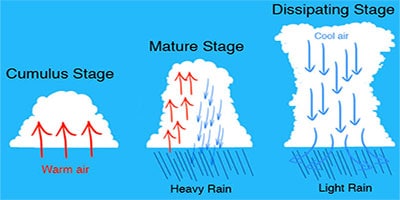
The clouds need to be very large to get rain with thunderstorms. Such clouds are called cumulus. It is so cold that the water zone begins to freeze, and ice crystals form at the cloud’s top. These crystals start to fall and become the Centers of forming large drops of water that move down. Large drops are flying down, and rain will soon pour out of the cloud.
The cloud builds high 10-15 thousand feet into the air. Then, that precipitation starts the fall. But there’s an issue here. Sometimes, storms can overgrow quickly and become 45 or 50 thousand feet tall, where jumbo jets usually fly. The typical airplanes that you see overhead and you get supercell thunderstorms.
They also have a graphic depicting that in a moment. Eventually, the thunderstorm will exhaust itself. It will run out of energy for updrafts and downdrafts. So heavy rain comes in the mature stage and thunderstorm development.
There are 3 things to form a thunderstorm:
- A source of moisture.
- An unstable atmosphere.
- Mechanism to trigger storm.
Remember this acronym: limb, lift, instability, and moisture. Lift is a convection with the warm air rising into the atmosphere, creating thunderstorm conditions. Instability is directly related to lifting once the air is up in the atmosphere and condensed. It creates clouds and, eventually, turbulent weather. The moisture over the ocean is typically suitable for tropical systems, a basic thunderstorm cluster.
How does a puffy white cumulus cloud turn into an immense tower and cumulonimbus that can deliver powerful winds dousing rainfall, hail, and tornadoes? To answer this question, let’s isolate one warm, humid blob of air as it rises as long as the blob is warmer than its surroundings. It rises, expands due to the lower pressure, and cools due to that expansion until it reaches the same temperature.
If the blob’s temperature drops to the dewpoint, water vapor will condense out of it, and a cloud will form. This condensation begins a cycle that drives the growth of the cloud. It is because when water vapor condenses, it releases heat. As soon as the cloud forms, the condensation returns to the block, and some heat will be lost due to expansion. Because the warmer air holds more moisture, the blob recovers some of the water vapor it lost.
When all that is done, the blob is still warmer than its surroundings, so it rises, and the whole thing starts all over again, with expansion, cooling, condensation, recovery of heat, and water vapor. Also, it rises again. It keeps happening over and over and over until the blob runs out of water vapor.
So when it’s hot and sticky, the abundant heat gives a blob of air a strong impulse to rise. The humidity provides a lot of water vapor to drive the growth of the clouds. It can produce clouds climbing to the stratosphere without anything stopping the process.
Now expand all this out, and we say that’s not one blob of air rising to make the cloud. But an ever-flowing conveyor of them draws a constant supply of warm, humid air into the developing cloud in the form of powerful winds known as updrafts. When the rain starts to fall from the clouds, this reduces downdrafts.
The storm can persist for some time like this. Especially if strong upper-level winds caused the cloud to become tilted, separating the updrafts and downdrafts enough they wouldn’t cancel each other. During the storm’s mature phase, it’s at this point that you will see abundant lightning and the possibility of hail and even tornadoes.
A layer of warm air above the ground, a typical atmosphere temperature profile, gets cooler the higher you go. Meteorologists call the presence of this warm layer a temperature inversion. Above the inversion, the normal temperature profile takes over. Forecasters and storm chasers often refer to this as the airmass being capped. This cap is most commonly associated with warm air riding over cooler, denser air near a warm front.
Or if there’s a warm, stagnant airmass stuck over a region. The air closest to the ground will cool overnight. But this cooling may not reach the air higher up before sunrise. As rising air reaches the cap, more warm, humid air parcels become trapped by this cap, blocked from reaching the cooler air above it. It causes a buildup of instability across this warm layer and frustration for storm chasers because this entire scenario will prevent storms from developing.
However, if conditions can break the cap, the air beneath it warms up enough to cancel out the inversion, Some powerful convection bursts past it. The sudden upward rush of warm, humid air causes explosive cloud development. A sudden rush of storm chasers to their vehicles often results in severe thunderstorms.
Different Types Of Thunderstorms
Scientists have classified thunderstorms into four categories:
1. Single-cell: Single cells are the pop-up thunderstorms you may see on a warm summer afternoon. They are caused by the ground’s heating, which heats the air above and causes air to rise. These thunderstorms may produce brief rain, minor hail, and some lightning but typically don’t last more than twenty to thirty minutes before dissipating.
2. Training thunderstorms occur when individual cells line up one behind the other. It occurs when one cell matures, and air currents create a new cell behind it. There are usually multiple cells in various stages of development, but they all follow the same path. These storms can produce large amounts of rainfall and may also have some hail, lightning, and possibly a weak tornado.
3. Squall lines: Squall lines are long individual cells lined up side by side. These can be associated with an advancing strong cold front. A strong rush of wind ahead of a squall line may be present, called a gust front. A gust front may have powerful winds, which speed up to sixty miles per hour or more. These storms can produce brief heavy rain, lots of lightning, hail, and tornadoes.
4. Supercells: A supercell is a large, rotating storm. One cell may be up to 15 miles in width. Supercell storms often occur along a dry line, a boundary between hot, dry, and warm, moist air. These two air masses may get squeezed together, causing the hot, dry air to override the warm, moist air, which stops the warm, moist air from rising.
If the two air masses are further pushed together, the warm, moist air may push through the hot, dry air, rising rapidly. This rising air may develop a rotation through areas where the surrounding winds move in different directions.
Once these conditions are in place, a supercell may last hours and move hundreds of miles. Supercells produce lots of rain and lightning, large hail, and may produce very strong tornadoes. Supercell storms are more common in the Great Plains area of the United States, although they can occur in many other US locations.
It’s essential to know about safety during a thunderstorm. Usually, lightning strikes high objects. Therefore, you shouldn’t hide from the rain under a tree during a thunderstorm. It is dangerous to be in the water or even near any water body during a thunderstorm as water conducts an electric current.
Did you notice that we always see lightning first during a thunderstorm, and only after that do we hear the thunder? It is because the lightning’s light reaches us almost instantly since the light’s speed is very fast. Thunder is a sound whose speed is much slower, so the thunder reaches us with a delay.
Thunderstorm Effects
Thunderstorms, a common natural phenomenon, can have a wide range of effects on the environment, infrastructure, and human activities. These effects vary from beneficial to severely destructive, depending on the storm’s intensity and the area it impacts. Here are some of the key effects of thunderstorms:
Positive Effects
Rainfall for Agriculture: Thunderstorms provide much-needed rainfall essential for crop irrigation and replenishing soil moisture levels, supporting agriculture worldwide.
Cooling Effect: The rainfall and cloud cover associated with thunderstorms can temporarily decrease temperatures, providing relief from hot weather conditions.
Cleaning of the Atmosphere: Thunderstorms help clean the atmosphere by removing dust and other particulates. Lightning also produces ozone, crucial in maintaining the earth’s atmospheric chemistry.
Negative Effects
Flooding: Heavy rainfall from thunderstorms leads to flash floods, especially in urban areas with poor drainage or regions where soil cannot absorb water quickly. Flooding causes significant damage to infrastructure, agriculture, and homes.
Lightning: Lightning strikes cause fires, damage buildings and electrical infrastructure, and directly threaten life. Lightning is responsible for numerous fatalities and injuries annually.
Wind Damage: Thunderstorms produce strong winds, including straight-line winds and downbursts, which cause significant damage to structures, trees, and power lines, leading to power outages and property damage.
Hail: Some thunderstorms generate hail, damaging crops, vehicles, roofs, and windows. Hailstorms are particularly devastating for agricultural regions, causing severe economic losses.
Tornadoes: The most severe thunderstorms spawn tornadoes, which are capable of causing extreme destruction, including leveling buildings, uprooting trees, and hurling vehicles. Tornadoes represent one of the most destructive aspects of thunderstorms.
Travel and Transportation Disruptions: Thunderstorms lead to visibility issues, flooding of roads, and turbulence for aircraft, disrupting ground and air travel.
Economic Impact: Thunderstorm damage can have a significant economic impact, requiring resources for cleanup, repair, and replacement of damaged infrastructure and assets.
Thunderstorm Facts
Thunderstorms are fascinating meteorological phenomena that occur all around the world. Here are some interesting facts about thunderstorms:
Definition and Formation: A thunderstorm is defined by lightning and thunder. It forms when warm, moist air rises into the atmosphere, cools, and condenses into a cumulonimbus cloud that reaches heights of up to 12 miles (20 kilometers) or more.
Electricity in the Atmosphere: Lightning separates positive and negative charges within a thunderstorm cloud. When the electrical charge becomes too great for the air to insulate, a discharge occurs, resulting in lightning. This happens within the cloud, between clouds, or between the cloud and the ground.
Thunder: Thunder is the sound produced by the rapid expansion and contraction of air heated by lightning. The sound of thunder travels for miles, but because light travels much faster than sound, we see lightning before we hear the thunder it produces.
Types of Thunderstorms: There are several types of thunderstorms, including single-cell (or “popcorn” thunderstorms), multicell cluster storms, multicell line storms (or squall lines), and supercells, which are the most severe and can lead to tornadoes.
Tornadoes: The most intense thunderstorms can spawn tornadoes, which are powerful columns of rotating air in contact with the cloud base and the earth’s surface. Supercell thunderstorms are particularly known for producing the most severe tornadoes.
Hail: Many thunderstorms also produce hail, which forms when updrafts in thunderstorms carry raindrops upward into extremely cold areas of the atmosphere, where they freeze into ice. Hailstones grow as they are lifted repeatedly by the updrafts until they become too heavy and fall to the ground.
Worldwide Occurrence: Thunderstorms are most common in tropical and subtropical regions but occur almost anywhere. The central United States, known as Tornado Alley, is particularly known for its severe thunderstorms and tornadoes.
Lightning Safety: Lightning is one of the leading weather-related causes of death and injury. When a thunderstorm approaches, it’s important to seek shelter inside a substantial building or hard-topped vehicle. The 30-30 rule is a good guideline: go indoors if the time between seeing lightning and hearing thunder is 30 seconds or less, and stay indoors for 30 minutes after hearing the last clap of thunder.
Rainfall: Thunderstorms can produce extremely heavy rain briefly, leading to flash flooding. Urban areas are especially vulnerable to flash floods due to the large amount of impervious surfaces.
Energy: A single thunderstorm releases as much energy as a 20-kiloton nuclear bomb, the size of the bomb dropped on Hiroshima during World War II.
From understanding the crucial ingredients that brew these powerful storms to witnessing the awe-inspiring dance of lightning and thunder, we’ve traversed the depths of atmospheric science together. We hope this expedition has not only sparked your curiosity but also deepened your appreciation for the majestic displays of nature’s force.
So, the next time dark clouds gather and the air tingles with anticipation, remember the incredible journey we’ve shared today. Thank you for being such an intrepid explorer of the skies with us. Until our next adventure into the wonders of weather, keep looking up and embracing the storm within!
More Articles:
How Cyclone Is Formed With Types
What Causes Lightning And Thunder
What Causes A Tornado To Form?
References:
“Thunderstorms, UCAR Center for Science Education.
National Severe Storms Laboratory. “SEVERE WEATHER 101 / Thunderstorm Basics”. SEVERE WEATHER 101. National Oceanic and Atmospheric Administration.
Yikne Deng. Ancient Chinese Inventions. Chinese International Press.
Table of Contents