Hey there, rain enthusiasts and curious minds alike! Have you ever found yourself gazing out the window during a downpour, wondering exactly how all those droplets made their journey from the sky to your doorstep? Well, you’re in for a treat!
Water can exist in three states: solid, liquid, and gas. When we want to get ice from water, we put the water in the freezer, cool the temperature, and get ice. So, how do we get water from gas? Well, We use the same process. We must take the water vapor, cool the temperature, and bring water. This is how clouds are created, which eventually leads to rain.
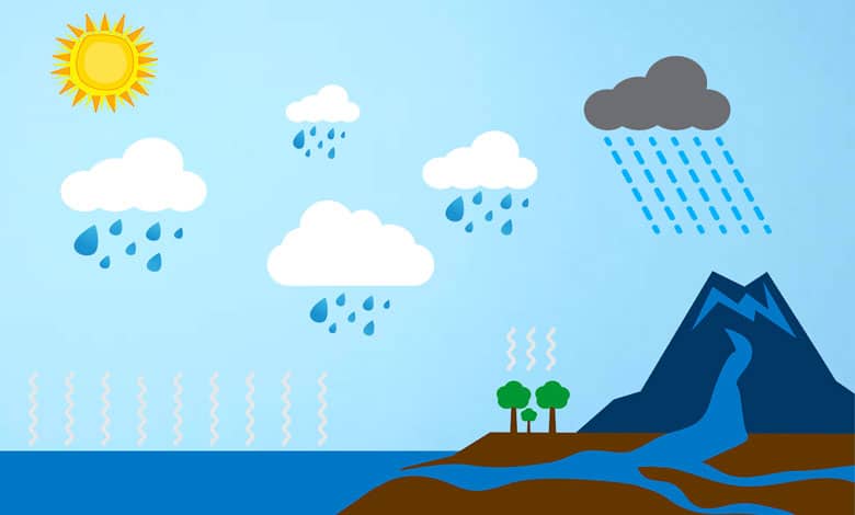
The Sun’s heat evaporates water from rivers, lakes, oceans, or even plants placed on the ground. It creates water vapor or water in gas rising in the air. As the water vapors rise in the air, the surrounding temperature cools, turning the vapor into water droplets.
The air is filled with dust, and these water droplets collide with the dust, forming the clouds in our sky. When this happens repeatedly, our clouds get bigger, and water droplets collide, making them heavier and heavier. Gravity takes over once the water droplets in the clouds are heavy enough, and the water droplets fall onto the Earth. In other words, it rains!
We’re diving into the fascinating world of weather to unravel the mystery behind rain formation. Grab your favorite cozy blanket and a warm cup of tea because we’re about to journey through the clouds to discover the secrets of rain.
How Is Rain Formed?
In the summer, it’s hot, and water vapor remains as a gas, leading to fewer water droplets in the clouds that are heavy enough to fall as rain. Did you know? When you combine all the colors in the world, you get white. That’s what light comes from the sun: a combination of all the existing colors. That’s the reason the clouds are white. They reflect the light coming from the sun. Before learning about rain formation, we need to understand the water cycle.
Water cycle explanation
The water cycle has a few main parts. They include:
- Evaporation.
- Condensation
- Precipitation.
- Collection.
Now, we will discuss the water cycle step-by-step process.
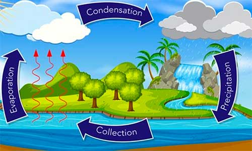
Step 1 – Evaporation: What sources of water are available for evaporation? It is where water turns from a liquid to a gas. Example: From a puddle to a pond, a pond to a lake, lakes to rivers, and rivers to seize.
The water is turned into a vapor and goes into the air. An unusual source of water comes from plants. Plants transpire essentially. It means losing water from their leaves similarly and sweating or perspiring. All of these processes cause water to evaporate.
Step 2 – Condensation: What happens once the water has entered the atmosphere? The water vapor will start to condense because of the low temperature of the atmosphere. When it does this, it forms clouds.
Step 3 – Precipitation: What happens next Once all the water is collected in the cloud? It falls back down. A fancy word for this is precipitation. Also, it can take many forms, including rain and snow. Precipitation is the process of water falling onto the surface of the Earth.
Rain is falling water in liquid form. Snow, ice, hail, and sleet are falling water in solid or frozen form. Precipitation that falls directly into the oceans becomes part of the surface ocean and can be churned by wave and wind action into ocean currents. Rain and snow falling directly on rivers and streams become one part of streamflow. Also, The rain that falls onto land takes a different path to the river.
Step 4 – Collection: Finally, rainfall collects the water on land. It soaks back into the earth, becoming groundwater from which plants and animals can drink. It may run over the soil, collecting in lakes, oceans, and rivers where the water cycle repeats.
How does rain form in clouds?
When seawater from big ocean waves gets blown up into the air, some can evaporate, leaving a particle of sea salt suspended. That speck of sea salt makes the perfect condensation nuclei. So why don’t we throw all these rainmaking particles over the areas that need rain the most, like dry farmlands? It’s called cloud seeding.
Raindrops aren’t as crystal clear as they seem. They’re a little dirty. Microscopic dirt particles from the earth get blown high into the atmosphere. When they get up, they are perfect for water vapor to condense. When water vaporizes, the individual molecules move so quickly and erratically. They find it hard to light up the right way to form bonds and turn them into liquid. Instead, they find condensing onto one of these microscopic particles much easier.
It’s called a cloud condensation nucleus to make a cloud. You need lots of these tiny little rain droplets, which means you need many nuclei to start things. When you have enough of them, that’s a cloud. More and more rain droplets and the cloud can get larger and larger. When enough of them, they start bumping into each other faster than they can evaporate. It makes raindrops that can grow larger and larger until they’re big enough to survive the fall down to the earth.
Raindrops are good trillions of these particles in the atmosphere. They’re dust, dirt, pollen pollution, fragments, mushroom spores, and even bacteria. Some scientists think that some types of bacteria and mushroom spores may have evolved to be the perfect cloud condensation nuclei so that they can build a raindrop around them to help them get back down to earth.
One kilometer-wide hypothetical cloud contains a volume of 1 billion cubic meters of water or raindrops. With some basic arithmetic, the cloud holds 250 metric tons of water! Strom clouds are huge for having such a high water density. Their average water content has been estimated at 50,000 metric tons. That’s enough water to fill 20 Olympic-sized swimming pools. An average cloudy droplet falls at naught point naught 3 kilometers per hour. It means it would take 33 hours to fall 1 kilometer.
Tiny droplets are heavy enough to fall gently to the ground in the light updraft. It creates a hazy light rain shower. But a stronger updraft keeps the water droplets in the clouds for longer. So they have more time to bump into each other. They unite, coalesce, and make bigger raindrops. Eventually, they become so big that the updraft can no longer support their weight. So they fall as giant raindrops or rainfall.
As they fall, turbulent air can blow them back into the cloud, bouncing around into even more raindrops and getting bigger. The longer a raindrop falls, the more likely it will get blown back into a cloud or another drop.
Types of Rainfall
Rain is water from the sky, but not all rain is equal. There are three types of rainfall. Orographic, frontal, and conventional.
Orographic rainfall: Orographic precipitation is known as relief precipitation. It is most commonly found in coastal regions with a mountain range. Wind from the sea contains a lot of moisture, and when it reaches a mountain, it cannot continue and is forced upwards. As the air mass goes upwards, it cools and eventually condenses into clouds. Soon after, the cloud can no longer hold more water and begins to rain.
Most precipitation ends up on the side facing the ocean, the windward side, while the other, or leeward side, gets little. It causes one side to be moist and full of vegetation while the other is dry.
Frontal rainfall: Next, there is frontal or cyclonic precipitation. When a warm, moist air mass meets a cold, dry one, the warm one rises, and the water vapor in the warm air condenses as it grows, forming clouds. Eventually, it will rain. If it is a warm front, the warm air will gradually rise to cause mild to prolonged moderate rainfall.
The warm air will rise quickly if it is a cold front, causing unstable weather, including thunderstorms. Frontal precipitation is widespread in the British Isles.
Convectional rainfall: The final type of rainfall is convectional precipitation. On hot days, the sun heats the ground. The ground then releases some of that heat, which warms the air. That warm air rises and cools to condense its water vapor into a liquid.
This causes rainfall to initiate almost instantly, usually without much warning. Since conventional precipitation relies on the sun to heat the ground, it is common in tropical regions, where the sun hits more directly and intensely. These three types of rainfall have ultimately shaped our society, providing the hydration necessary for vegetation to exist.
The Sun is beating down on tropical waters, powering the weather systems of the globe. Moisture evaporates from the warming ocean and rises to create great storms. The whims generated out at sea sweep inland across the continent. As they travel across the Sahara, they make the biggest sandstorms. They are blowing sand halfway around the world to fertilize the Amazon jungle.
Wind blowing across the Indian Ocean collects moisture and sweeps northwards towards the Himalayas. As the air rises, it cools. The water it carries condenses into clouds and then falls as the life-giving rains of the monsoon. So air currents powered by the Sun carry wet air to the middle of continents.
Causes of Heavy Rainfall
Heavy rainfall can occur due to various meteorological factors and atmospheric conditions. Here are some common causes of heavy rainfall:
Atmospheric Instability: When the atmosphere is unstable, with warm and moist air rising rapidly, it can form towering cumulonimbus clouds. These clouds have strong updrafts that can produce intense rainfall.
Frontal Systems: Heavy rainfall often occurs along the boundaries between air masses of different temperatures and moisture content. When a warm or cold front interacts with moist air, it can trigger the uplift of warm, moist air, leading to heavy precipitation.
Orographic Lifting: When moist air encounters elevated terrains, such as mountains or hills, it is forced to rise over the topography. As the air rises, it cools and condenses, resulting in heavy rainfall on the windward side of the mountains.
Convection: Convection occurs when warm air near the surface rises rapidly, carrying moisture with it. As the air ascends, it cools and forms clouds, eventually leading to heavy rainfall. Convectional rainfall often occurs in tropical regions with ample heat and moisture.
Tropical Cyclones: Hurricanes, typhoons, and tropical storms are powerful weather systems characterized by intense rainfall. These cyclones derive energy from warm ocean waters and can produce heavy rain over a wide area, resulting in flooding.
Monsoonal Systems: Monsoons are seasonal wind patterns that bring heavy rainfall to specific regions. Monsoons are associated with the seasonal reversal of wind directions, typically influenced by temperature differences between land and sea. The interaction between these winds can result in prolonged periods of heavy rainfall.
Atmospheric Moisture Content: High atmospheric moisture levels provide the necessary fuel for heavy rainfall. When abundant moisture is available, whether from nearby water bodies, evaporation, or atmospheric transport, it can contribute to the formation of heavy precipitation.
Last Words
We hope this exploration has not only quenched your thirst for knowledge but also sparked a newfound appreciation for those rainy days. So, next time the skies open up, remember the amazing process unfolding above you. Thanks for joining us on this watery adventure! Stay curious, and don’t forget to splash in a few puddles along the way. Until next time, keep looking up!
More Articles:
Why Are Clouds White? – Dark & White Cloud Explanation
What Causes The Smell After Rain?
How Do Clouds Float? – Floating Clouds Explanation
Why Don’t Sheep Shrink When It Rains?
What Is Rain Shadow Effect? – By Mountain Diagram
Is The Sky Really Blue? – Blue Sky Scientific Explanation
References:
Steve Kempler. “Parameter information page.” NASA Goddard Space Flight Center.
Mark Stoelinga. Atmospheric Thermodynamics. University of Washington.
Glossary of Meteorology. “Relative Humidity.” American Meteorological Society.
Naval Meteorology and Oceanography Command. “Atmospheric Moisture.” United States Navy.
Table of Contents