Rain Shadow Effect is a fascinating meteorological phenomenon that shapes ecosystems and climates across the globe. This effect occurs when mountains block the passage of rain-producing weather systems, casting a “shadow” of dryness on the leeward side. It’s a story of wind, water, and topography, intricately woven to create distinct environments.
Rain comes from a few different places, like the ocean. The sun causes ocean water evaporation that evaporates ocean water rising and becomes clouds. Then the wind blows those clouds over the mountain, and eventually, those clouds will rain.
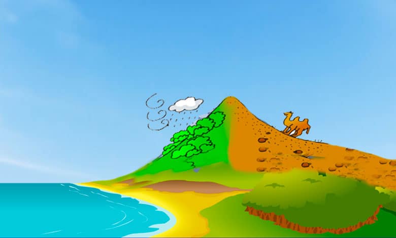
Rain shadows are dry areas on the backsides or the downwind side of mountains. The mountain creates a shadow of dryness. Western Washington is famous for its rain. But a strikingly different landscape is on the other side of the Cascades. Washington’s the Evergreen State, but half of it’s Everbrown! There’s a rainshadow north of the Himalayas in Asia.
A rainshadow west of The Great Dividing Range in Australia and east of the Sierra Nevada Mountain Range in California. That rainshadow southwest of Manua Kea on the Big Island of Hawaii. Do you want to know about the rainshadow effect? You need three essential items: an ocean nearby, winds blowing steadily onshore, and a mountain range to block the traveling air mass.
What Is Rain Shadow Effect?
A rain shadow is formed when moist air encounters a mountain range, which significantly decreases rainfall on the mountains’ leeward side (sheltered from the prevailing winds). The process can be explained as follows:
Windward Side: Moist air from an ocean or a large water body is carried by prevailing winds towards a mountain range. As the air encounters the mountains, it is forced to rise due to the topography.
Orographic Lift: As the air is forced to rise, it undergoes a process known as orographic lift. As the air ascends, it cools adiabatically (due to expansion) and reaches its dew point, resulting in condensation and the formation of clouds. This leads to precipitation on the windward side of the mountains, typically characterized by high rainfall.
Rain Shadow Effect: Once the air passes over the mountaintops and descends on the leeward side, it undergoes adiabatic warming. As the air descends, it compresses and warms, causing the moisture content to decrease. The descending air mass becomes drier, creating a rain shadow effect.
Reduced Precipitation: The descending, drier air on the leeward side inhibits the formation of clouds and rainfall. As a result, the area on the leeward side experiences significantly less precipitation than the windward side.
The rain shadow effect can lead to arid or semi-arid conditions on the leeward side of the mountain range, often resulting in desert or steppe-like environments. Some famous examples of rain shadows include the Atacama Desert in Chile (due to the Andes Mountains) and the Great Basin Desert in the western United States (due to the Sierra Nevada and Cascade Mountains).
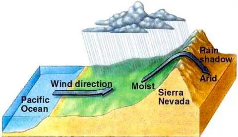
We can illustrate this by observing the effect of the prevailing wind and a mountain range on the region’s rainfall level. Let’s begin at the ocean, where the water evaporates and is held in the air as water vapor. Why does wind carry all this moist air over the land? As the air rises from the mountain, it expands and cools because the cool air can carry less water vapor than the warm air.
Evaporation on the surface of the ocean creates moist air. Prevailing winds push the wet air inland until it hits the base of the mountains. The air is forced to rise. As the airlifts, it expands and cools. Cooler air can’t hold as much moisture, so clouds form, and it rains a bunch, resulting in a lush, green landscape.
Now, dry air mass crosses the mountains and begins to sink on the leeward side of the range. It compresses and warms, promoting evaporation. Dry air warms 1 degree Celsius per 100 meters of elevation drop. Some of the driest places worldwide exist because of the rainshadow effect. Let’s look at the rain shadow effect diagram.
What causes a rain shadow? When the wind blows up a mountain, the air moves into an area with lower pressure, expanding and cooling the rising air. When air cools, its capacity to hold moisture in the form of water vapor decreases. Water vapor is the gaseous form of water. As the air continues to rise the mountain, it cools to the point it’s at its maximum capacity to hold water vapor.
When air is at its maximum capacity, it is at 100% relative humidity. Further cooling will cause excess water vapor to condense or turn into liquid water. This forms clouds. When moist air rises, it expands, cools to the dew point, condensation occurs, and clouds form. If enough condensation occurs, rain or snow will fall out of the clouds. As long as the air rises, condensation, clouds, and possibly rain or snow will occur.
Windward side effect
The windward side is the mountainside where the wind blows up the mountain. Many world areas experience large amounts of rain or snow where the air is forced up mountains. The wind blows up the mountain, and the air mass encounters less pressure. It turns out that as you move up in altitude.
There’s less air pressure, so as this air mass moves up. It begins to expand, and its temperature drops as that air mass expands. It is referred to as adiabatic cooling. Also, adiabatic means no addition or loss of heat going out here.
The western parts of Oregon and Washington states are good examples of this process. This side of the mountain can support a lot of plant life plants. It’s the windward side because it’s the side where the wind is blowing from the ocean, hitting the mountain, and going up.
Leeward side effect
As air flows down the other side of the lee side of the mountain, it starts to warm. The warming is caused by the air getting squeezed together and moving downward into higher air pressure. Warmer air can hold more water vapor, so condensation does not occur when air sinks. If there is no condensation, there are no clouds and, therefore, no rainfall.
There is not a lot of rain, and the temperature will increase. So this side of the mountain is usually hotter than the other side. Because the air is sinking here, and it’s totally dry. There’s no rain at all or very little rain. So this side of the mountain is usually like a desert.
Dry or desert conditions prevail on the leeward side, known as the rain shadow area. The mountain’s leeward side remains dry because the air passes through it and becomes warm. Eastern parts of Oregon and Washington are examples of where the rain shadow occurs. At the same time, Laurel Mountain in Western Oregon receives over 119 inches of yearly precipitation. On the mountains’ lee side, Bend, Oregon, receives only about 12 inches of yearly rainfall.
The orographic effect is known for the air and temperature difference between the mountain’s windward and leeward sides. You will experience significant differences in climate depending on which side of the hill you will be on.
The Rainshadow Effect has been a great help to geologists in the Pacific Northwest. The Cascades have cast a rainshadow on Washington’s Channeled Scablands, our desert landscape that has yielded many clues about the Ice Age Floods, the Columbia River Basalts, and other wonders of our geologic past.
How is a Rain Shadow formed?
A rain shadow is a dry area on the leeward side (the side sheltered from the wind) of a mountainous area, which blocks precipitation and clouds from passing over, creating a distinctively drier region. The formation of a rain shadow involves several steps linked to the movement of air masses and their interaction with geographic features. Here’s a simplified explanation:
- Windward Side Moisture Uptake
The process begins when moist air masses move toward a mountain range. These air masses are forced upwards into higher altitudes as they encounter the mountains. This upward movement is known as orographic lift.
- Cooling and Condensation
As the air rises, it cools down. Cooler air can hold less moisture than warm air, leading to condensation. This condensation forms clouds and, eventually, precipitation, which falls on the windward side of the mountain. This area receives significant rain and is often characterized by lush vegetation.
- Leeward Side Descent
After the air mass has lost much moisture on the windward side, it crosses over the mountain peak to the leeward side. By this time, the air is drier.
- Warming and Drying
As the air descends on the leeward side, it warms up. This warming increases the air’s capacity to hold moisture, decreasing its relative humidity. Since the air is now warmer and drier, the likelihood of precipitation decreases significantly.
- Rain Shadow Formation
The result is a rain shadow, an area with significantly reduced precipitation and moisture, leading to drier conditions than the windward side. These areas can be deserts or semi-arid regions, depending on the extent of the moisture blockage and the size of the mountain range.
Example
A classic example of a rain shadow is the eastern side of the Sierra Nevada mountains in the United States. The western side, facing the Pacific Ocean, receives heavy rainfall, while the eastern side, in the shadow of the mountains, is the much drier, arid Great Basin region.
Implications
Rain shadows significantly affect affected regions’ climate, agriculture, and water resources. They contribute to creating deserts and semi-arid zones and influence local climates, affecting biodiversity, agriculture, and human settlements.
Understanding the dynamics of rain shadows is crucial for water resource management, agricultural planning, and conservation efforts in these regions, ensuring sustainable development and habitat preservation despite the challenging conditions.
What is Rain Shadow effect on humans?
The rain shadow effect profoundly impacts human activities, settlements, and the overall environment in which people live. Rain shadows influence agriculture, water resources, population distribution, and economic development by creating areas of significantly reduced precipitation on the leeward side of mountain ranges. Here are some of the key ways the rain shadow effect impacts humans:
- Agriculture and Food Production
Water Scarcity: The reduced rainfall in rain shadow areas leads to water scarcity, which can significantly limit agricultural activities. Crops that require a lot of water may not be viable, pushing communities to adapt by cultivating drought-resistant crops or employing irrigation, which is costly and resource-intensive.
Soil Conditions: Drier conditions affect soil quality, reducing fertility due to lack of moisture and organic matter. This necessitates using fertilizers and amendments to support agriculture, increasing the cost and environmental impact of farming.
- Water Resources
Access to Freshwater: Rain shadow regions face challenges accessing sufficient freshwater for drinking, sanitation, and irrigation. This leads to the need for water importation from wetter areas or the development of desalination plants in coastal regions, both of which have economic and environmental costs.
Conservation and Management: Water scarcity necessitates innovative water management and conservation strategies, such as rainwater harvesting, recycling wastewater, and implementing strict water usage regulations to ensure sustainability.
- Population Distribution
Settlement Patterns: Historically, human settlements have flourished in areas with adequate water supplies. As a result, rain shadow regions might have lower population densities due to the harsher living conditions and limited agricultural potential. However, modern technology and infrastructure improvements (like water transport and desalination) have allowed cities to develop and grow in these areas.
Urban Development: The growth of urban areas in rain shadow regions may strain existing water resources, leading to increased competition for water between agricultural, industrial, and residential uses.
- Economic Development
Industry and Employment: The type of industries that can develop in rain shadow areas might be limited by water availability. Industries requiring large amounts of water may be unsustainable, influencing the job market and economic opportunities available to the residents.
Tourism: Some rain shadow areas, especially those with unique landscapes and ecosystems, can become tourist destinations, providing economic benefits. However, tourism development must be balanced with the sustainable management of natural resources.
- Adaptation and Resilience
Innovation and Adaptation: Communities in rain shadow areas have developed various adaptation strategies, including terracing, drip irrigation, and selecting crops suited to dry conditions, showcasing human resilience and innovation in environmental challenges.
Climate Change Vulnerability: Climate change exacerbates water scarcity issues in rain shadow regions, making them more vulnerable to droughts and heat waves. This underscores the importance of climate resilience and adaptation strategies to mitigate these impacts.
In summary, the rain shadow effect challenges human societies regarding water scarcity, agriculture, economic development, and settlement patterns. However, it also drives innovation in water management and conservation, agricultural practices, and urban planning, illustrating the complex relationship between humans and their environment.
We emerge with a richer understanding of how landscape and atmospheric conditions converge to sculpt the natural world. This knowledge not only deepens our appreciation for the planet’s diverse climates but also underscores the complexity of ecological systems influenced by seemingly simple geographic features.
Learn more:
What Is Coriolis Effect On Wind?
What Causes The Smell After Rain?
References:
Whiteman, C. David. Mountain Meteorology: Fundamentals and Applications. Oxford University Press. ISBN 0-19-513271-8.
Glossary of Meteorology. “trade winds.” Glossary of Meteorology. American Meteorological Society.
Rain Shadows by Don White. Australian Weather News. Willy Weather.
Table of Contents