Orographic effect is a phenomenon that beautifully illustrates the interaction between Earth’s topography and its weather patterns. As mountains act as natural barriers to air movement, they force moist air to rise, cool, and release precipitation. This creates lush landscapes on windward slopes and arid conditions on the leeward side.
In orographic precipitation, winds move there up and over a mountain barrier. The forced descent of warm, moist air over a mountain barrier produces precipitation. Moist oceanic air arrives at the coast. The air cools as it is forced up the slope. It cools because atmospheric pressure decreases with elevation. When cooling is sufficient, water vapor begins to condense.
Farther up the slope, precipitation occurs. The temperature cools but at a slower rate because of latent heat release. It is now hot because of the added latent heat release and dries since its moisture has been removed. When you see orographic or relief, you want to think of mountains.
There are major mountain belts, for example, on the west side of North America, where you’ll find the Rockies or the Himalayas over in Asia. Planetary winds are curved due to the Coriolis effect, the earth rotating. Water has a high specific heat, so it takes a long time to heat up and cool down. Also, the land has a low specific heat. So it heats up and cools down fast.
What Is The Orographic Effect?
The orographic effect is the charm used to describe changes to airflow. When the land’s topography airs upward, these changes can cause disturbances in the weather system. As the air mass gains altitude, it cools down, raising the relative humidity to 100%. It also creates orographic clouds, which serve as a source of precipitation. The air will be saturated if you can drop the air temperature to the dew point temperature. At that point, a cloud is going to begin to form.
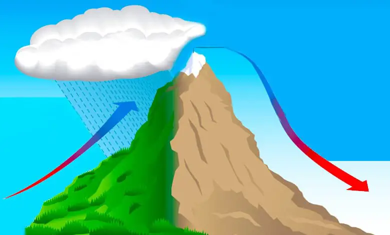
The big mountain has two sides: the windward and leeward sides. Windward winds travel up the side of the hill and bring moist air up the mountainside. On the leeward side, winter is dry as they descend the mountains. Winds are significant as they are the driving function of the orographic process.
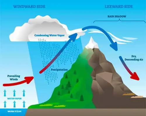
It is another key component of the orographic effect. The orographic lift can cause orographic precipitation along the windward side. On the other side of the mountain, we see the rain shadow effect, mainly in the desert area.
Windward side
The windward side of a mountain is the side that faces the prevailing winds. Prevailing means the way the winds usually blow. As a result, the windward side is the west side. Because the air rises along the windward side and with cooling air, its relative humidity rises.
Therefore, the windward side tends to be the side that gets clouds. Clouds produce precipitation. Additionally, the windward side also tends to be the vegetated side. So everything on this side of the mountain will be cool and wet.
Leeward side
On the other side of the mountain, the leeward side. The air begins to sink the mountain, and when cool air sinks, it becomes compressed. Also, it warms and evaporates. The backside of the mountain is called the leeward side. The air descends on the leeward side.
As the air is falling, it’s warming. Warming air means dropping relative humidity. The leeward side is a side that’s sheltered from the prevailing winds. Because of this, the leeward side tends to be the dry side. In many places, the leeward side tends to be a desert.
In California, the leeward side is also referred to sometimes as the rain shadow. Or the side of the mountain in the rain shadow, indicating that it does not get a lot of precipitation. Again, leeward and rain shadow both indicate dry or a desert. So, the leeward side becomes a desert climate with drier climates.
Warm air comes from the ocean and rises upward. Expanding warm air creates a rain shadow. The warm air cools and condenses, so this mountainside will be wet and cold or cool. On the other side of the mountain, there will be a desert. It changes the climate and the weather. It is what we call the Orographic effect.
According to the National Oceanic and Atmospheric Administration, the dry lapse rate is when the temperature of a parcel of dry air decreases as the parcel is lifted into the atmosphere. The dry adiabatic lapse rate is 5.5 degrees Fahrenheit for 1000 feet or 9.8 degrees Celsius per kilometer.
Moisturing rate is when the temperature of a part of saturated air decreases. As the partial is lifted in the atmosphere, this rate is not constant like the dry lapse rate. However, it is dependent on the partial temperature and pressure.
Why is California green and lush while Nevada is dry or arid?
- Coastal cities receive moisture from the ocean. There’s more humidity in the air, and they can get more rain.
- The warm, wet air from the Pacific rises over California, Seattle, and Washington and releases rain on them.
- It then heads eastward towards Nevada.
How does the Orographic effect affect climate?
The orographic effect significantly influences the climate of different regions worldwide by altering precipitation patterns and temperatures based on the area’s geography, particularly in regions with prominent mountain ranges. This effect occurs when moist air masses are forced to rise over mountain barriers. Here’s how the orographic effect impacts climate:
- Increased Precipitation on the Windward Side
As moist air ascends the windward side of a mountain range, it cools and condenses into clouds, leading to precipitation in the form of rain or snow. This process creates a wetter climate on the windward side, supporting lush vegetation and diverse ecosystems, such as rainforests in some locations.
- Rain Shadow on Leeward Side
After the air mass has risen and cooled, losing much of its moisture on the windward side, it descends on the leeward side of the mountain. As it descends, it warms up, reducing its relative humidity and ability to produce precipitation. This results in drier conditions on the leeward side, creating a rain shadow effect where the climate is significantly drier than on the windward side. This can lead to the formation of deserts or semi-arid regions.
- Temperature Variations
The orographic effect also causes temperature variations. Elevated areas and mountainous regions generally experience cooler temperatures than the surrounding lower land due to decreased atmospheric pressure at higher altitudes, which causes air to cool as it rises. Conversely, the leeward side, which experiences downslope winds (katabatic winds), can be warmer due to adiabatic heating as the air compresses and warms while descending.
- Microclimates
The orographic effect can create microclimates, small areas with climate conditions that differ from the surrounding region. For example, valleys can be cooler or humid than exposed mountain slopes. The varying elevations and aspects (directions faced) of mountain slopes can significantly affect sunlight exposure, wind patterns, and precipitation, creating diverse microclimates within a relatively small area.
- Seasonal Variations
The impact of the orographic effect can vary seasonally, especially in areas where prevailing wind directions change over the year. For instance, a region on the windward side of a mountain range during one season may experience drier conditions in another season if the direction of the moist airflow changes.
- Influence on Vegetation and Ecosystems
The differences in precipitation and temperature due to the orographic effect lead to distinct vegetation zones and ecosystems on mountains’ windward and leeward sides. The wetter windward side can support forests and agricultural activities, while the drier leeward side may support grasslands, shrublands, or desert vegetation.
- Impact on Human Activities
The orographic effect influences human activities such as agriculture, water resources management, and settlement patterns. Areas with abundant precipitation may support diverse agricultural practices, while drier rain shadow regions may face water availability and land use challenges.
In summary, the orographic effect plays a crucial role in determining the climate of mountainous regions, affecting precipitation patterns, temperature, the development of microclimates, ecosystem diversity, and human activities. Understanding this effect is essential for climate science, meteorology, ecology, and regional planning efforts.
Characteristics of orographic rainfall
Here’s a breakdown of the key characteristics of orographic rainfall:
- Caused by Mountains or Elevated Terrain:
Orographic rainfall is directly influenced by the presence of mountain ranges or high ground, which forces air masses to rise and cool, leading to rainfall.
- Windward and Leeward Sides:
Windward Side: The side of the mountain where moist air is forced to rise is known as the windward side. This is where most of the rainfall occurs as the rising air cools, condenses, and forms precipitation.
Leeward Side: On the opposite side of the mountain, known as the leeward side, the air descends, warms, and becomes drier, often leading to a rain shadow effect where little to no rain falls.
- Cooling of Air Due to Ascent:
As moist air rises over the mountain, it cools adiabatically (without heat exchange with the environment), which causes the moisture in the air to condense and form clouds, eventually leading to rainfall.
The cooling occurs because the atmospheric pressure decreases with altitude, causing the air to expand and lose heat.
- Condensation and Cloud Formation:
As the rising air cools to its dew point (the temperature at which air becomes saturated with moisture), condensation occurs, forming clouds. If enough moisture is present, this results in precipitation.
- Heavy Rainfall on the Windward Side:
The windward side of mountains or hills often experiences heavy rainfall, especially in regions where moist winds from the ocean are forced up over the mountains, such as in coastal regions with mountain ranges.
- Rain Shadow Effect on the Leeward Side:
After the air has passed over the mountain peak and begins to descend on the leeward side, it becomes warmer and drier, leading to much less precipitation or arid conditions. This phenomenon creates a rain shadow region, where rainfall is significantly reduced.
Famous examples of rain shadow areas include Death Valley (USA) and the Patagonian Desert (Argentina).
- Frequent in Coastal and Mountainous Areas:
Orographic rainfall is most common in coastal regions with significant mountain ranges. For example, regions like the Western Ghats in India, the Andes in South America, or the Rocky Mountains in North America experience this type of rainfall.
- Seasonal Influence:
The intensity of orographic rainfall can be influenced by seasonal winds or monsoons. For example, in India, the Southwest Monsoon brings moist air from the Indian Ocean, causing heavy orographic rainfall along the Western Ghats during the rainy season.
- Localized Rainfall:
Orographic rainfall tends to be localized to areas near or along the windward slopes of mountains. Beyond the mountain range, rainfall decreases drastically.
- Cloud Types Associated with Orographic Rainfall:
Stratus and nimbostratus clouds are often associated with orographic rainfall, as these clouds form when moist air rises steadily over a long period. Cumulonimbus clouds may also develop in more intense or unstable atmospheric conditions, leading to heavier showers or thunderstorms.
- Cooling and Precipitation Patterns:
As the moist air rises, it cools at a rate of about 6.5°C per 1000 meters. The actual precipitation varies depending on the moisture content of the air and the height of the mountains.
The amount of rainfall generally increases with the altitude of the windward side, making higher slopes particularly wet.
Examples of Orographic Rainfall:
Himalayas: The Indian monsoon winds bring moisture-laden air, causing heavy orographic rainfall on the southern slopes of the Himalayas.
Western Ghats (India): Monsoon winds from the Arabian Sea bring heavy rainfall on the windward side of the Western Ghats, while the leeward side (e.g., Deccan Plateau) remains much drier.
Sierra Nevada (USA): Moist air from the Pacific Ocean causes rainfall on the windward side, with desert conditions in the leeward Great Basin area due to the rain shadow effect.
Last Words
We gain not just an understanding of this meteorological phenomenon but also an appreciation for the profound impact of geography on climate and ecosystems. This knowledge enriches our view of the natural world, revealing the intricate dance between the earth and its atmosphere that shapes our environments.
References:
Stull, Roland. Practical Meteorology: An Algebra-based Survey of Atmospheric Science. University of British Columbia.
Whiteman, C. David. Mountain Meteorology: Fundamentals and Applications. Oxford University Press.
Rain Shadows by Don White. Australian Weather News.
Table of Contents