Hello, weather watchers and curious minds alike! Have you ever found yourself marveling at the power of nature, particularly the swirling, twirling dance of hurricanes seen from satellite images? These massive storms are awe-inspiring and a testament to our planet’s dynamic and powerful forces. But what exactly sparks the birth of a hurricane, transforming serene ocean waters into a ferocious force of nature?
Hurricane is a natural phenomenon and disaster that brings torrential rain and flooding. They’re measured on wind speed. When the winds in the middle of the storm reach an average of 74 miles an hour, it becomes a hurricane. It is a vast and intense storm. But where do these giant storms come from? A hurricane starts with the warm water found near the equator. It typically only forms in tropical regions where the ocean is at least 80 degrees Fahrenheit.
The warm waters evaporate, creating warm, moist air, which acts as fuel for the storm. The wind is also needed for a hurricane to form. Many hurricanes in the United States are caused by winds blowing across the Atlantic Ocean from Africa. Hurricanes usually form within 5 to 15 degrees latitude north and south of the equator.
Many of these ripples travel thousands of miles toward the Atlantic in every hurricane season. But only a few have ever become hurricanes. Not all hurricanes are born this way. Hurricanes formed from a cluster of thunderstorms suck up the warm moist air and move it high into Earth’s atmosphere.
The warm air is then converted into energy that powers the Hurricane’s circular winds. These winds spin around a low-pressure center called the eye, providing a 20-30 mile radius of eerie calm encircling.
Grab your raincoat and join us as we go on a whirlwind adventure to uncover the mysteries behind the formation of hurricanes. Whether you’re a storm chaser at heart or simply fascinated by the weather’s wonders, this journey will surely blow you away. Ready to dive into the eye of the storm? Let’s get started!
What is Hurricane?
Most people will know these tropical storms as hurricanes. However, they’re called other things in different parts of the world. Hurricanes refer to tropical cyclones that occur in the Atlantic Ocean.
- However, tropical storms that occur in the Indian Ocean are called cyclones.
- They are called typhoons when they occur in the Pacific Ocean and hit the coast of China, Japan, or Northern Australia.
All tropical storms can perform and occur in the world’s tropical regions. They don’t exactly happen along the equator, but they happen a few degrees north and a few degrees south of the equator. By far, most tropical storms occur in the Pacific Ocean, and these form in the middle of the Pacific Ocean. They move westwards, coming into contact with the islands of Japan, the Philippines, China, and places like that.
Structure: The structure of a hurricane is separated into three different parts.
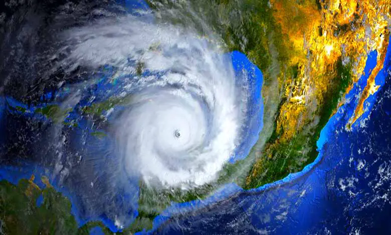
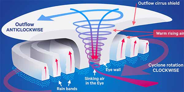
1. Eye: Firstly, the eye of the storm is its characteristic center. It is located right in the center of the whole stormfront. It usually measures 20 to 30 miles wide or 10 to 65 kilometers. Also, it has low air pressure; generally, the wind is calm over here. There are no clouds.
2. Eyewall: Heavy clouds surround the eyewall. The hurricane’s most terrible part and the highest speed winds are found here. In the eyewall, there is the highest sustained wind speed. They have to exceed 130 kilometers an hour if the canoe is known as a hurricane. It’s primarily a cloud-free area because the air is sinking, probably the calm part of the storm.
Generally speaking, the eye of the storm shrinks the stronger the storm becomes. The highest wind speeds are found around the eyewall. The section is directly around the eye of the storm. Wind speed here can reach more than 320 kilometers an hour. It is where the real wind damage of the storm occurs.
3. Rain bands: These tend to curve around spirally. They’re capable of producing heavy bursts of rain and wind. Also, they can extend outwards from the eye of the storm. Sometimes as much as five hundred and fifty kilometers.
What causes a hurricane to form?
Hurricanes or tropical cyclones form over oceans in the autumn when the summer sun has warmed the seas. When wind moves over the warm ocean towards an area of low-pressure water, it evaporates and rises into the atmosphere. As it grows, the water vapor condenses to form clouds. Condensing releases the heat stored in the water vapor, which warms the air around it.
The warm air rises and creates a column of clouds with low pressure beneath it. Way up there, the water vapor condenses back into liquid water droplets. Water droplets in the atmosphere form clouds, including big stormy cumulonimbus clouds. As the warm air rises upward, the winds begin blowing in a circular pattern around a center. The spiraling winds gather up a cluster of big thunderstorm clouds.
Surrounding air rushes in to fill this pocket of low pressure. A cycle of winds and a cluster of thunder is called a tropical disturbance. The system is classified as a tropical storm when the wind speed reaches 39 miles per hour. It is given a name to help meteorologists identify it. If the storm encounters a particularly warm patch of ocean, that can be enough to turbocharge the system to become a hurricane.
The storm becomes a hurricane once the spinning winds reach 74 miles per hour. They can be 10 miles high and over 1,000 miles across. Once a hurricane hits land, it runs out of warm, moist air, weakening its winds. But the storm can still cause lots of damage to communities near the coast.
The winds twist around the eye of the storm. It is known as the Coriolis effect. Moreover, it is caused by the force of the Earth’s spin. It can only happen between five and fifteen degrees latitude on either side of the equator. A vertical wall of intense rainstorms surrounds the eye called the eyewall.
The winds around the eyewall are strong enough to blow a house away. As a hurricane approached land, the disturbances in the water caused the sea level to rise. When it reaches land, this becomes a storm surge. A body of water that floods the coastline can travel many miles inland.
Scientific explanation: The heat from the ocean is the hurricane’s energy source. The high moisture levels in the atmosphere will cause storm clouds to expand. Winds rotate about a central point, and a tropical depression is born.
After a few days of drifting, winds in the center circled a gale force. The rain clouds have expanded the area, which is powerful enough to be called a tropical storm. The tropical storm is heading for an ocean region where the sea is hot.
At 12 hours later, the energy released from the ocean has powered up the winds to a critical speed. It’s now a hurricane! It resembles a whirlpool of space clouds, and the eye is in its middle. It’s a relatively small circle of calm weather, typically 30 miles wide.
This clearer eye is then surrounded by a ring of fused towering rainstorms known as the eyewall. It’s the most dangerous part. Under the eye, the wall blows the fastest winds. Within the eyewall, warm air currents violently fan outwards at the top.
Hurricanes formation step by step: There are two major steps for hurricane formation, which are given below:
Step 1 – Tropical storm formation
How do tropical storms form? It requires quite a warm water temperature, generally above 27 degrees. This heat and moisture rise due to the convection currents, forming large clusters of thunderstorms. These thunderstorms may begin to rotate due to the Coriolis force of our planet.
The resulting organized masses of thunder clouds moved in a circular motion depending on the hemisphere, which moved in different directions. Air is deflected to the right in the northern hemisphere and left in the southern hemisphere.
The swirling clouds and rain clouds become more organized as they circulate the center of this storm. They’re known as tropical storms when wind speeds are less than 38 miles per hour, approximately 61 kilometers an hour. It is classified as a tropical depression.
However, this is a tropical storm once the wind speed gains and reaches a 39-mile-an-hour limit. It’s given a name to identify it, and various organizations worldwide have begun tracking it because it could turn into a hurricane.
Step 2 – Tropical storms to hurricanes formation
Tropical storms gain energy from the sea. The rising water vapor fuels it, and they pull in all of this energy from the warm ocean sea surface temperatures. The energy of these storms can constantly increase. But it’s not until they reach 74 miles or approximately 119 kilometers an hour that they are officially classified as a hurricane.
Hurricanes’ durability: These hurricanes can last more than two weeks. Depending on the sea surface temperature, they can gain additional energy as they move across the open waters. However, when they cross or come into contact with land, they rapidly lose their energy source and begin to lose energy.
The wind speeds gradually reduce until. Eventually, they peter out and no longer have this hurricane force-time them. They then revert to small tropical storms and will eventually dissipate over land.
What is the effect of hurricane?
Most of the damage may come from the flooding and not necessarily the wind. Once a hurricane reaches land, it can travel hundreds of miles, causing huge damage. But without the warm ocean to fuel it, it will eventually dissipate. A wind scale is used to grade the intensity of a hurricane. Let’s look at the effect of the hurricane by category.
- Category 1- Winds are clocked between 74 and 95 miles per hour and may result in some damage.
- Category 2- The storm has winds of 96 to 110 miles per hour, and the damage can be expected to be extensive.
- Category 3- Hurricanes are extremely dangerous, with wind measured from 112 to 129 miles per hour. The damage will be devastating.
- Category 4- Hurricane with winds reaching 156 miles per hour. The damage will be unbelievable.
- Category 5- The damage is catastrophic, with winds exceeding 157 miles per hour.
On September 20th, 2017, a category five hurricane struck the island of Puerto Rico. The damage and loss of life have been devastating. All 3.4 million residents were plunged into a deep crisis. This hurricane was named Maria, and it affected many of the islands of the Caribbean.
Destruction is caused by the high winds and the tremendous amount of water that brings massive and widespread flooding. The most dangerous component when hurricanes come near land is storm surge. Storm surge is caused when winds from an approaching hurricane push water toward the shoreline up to 20 feet above sea level and extend 100 miles. 90% of all hurricane deaths are the result of storm surges.
While hurricanes can cause mass devastation like other natural disasters. They serve a higher purpose within the global ecosystem. Hurricanes help regulate our climate by moving heat energy from the equator to the poles, keeping the earth’s temperature stable. Over time, science has helped us understand hurricanes better and predict their paths.
What to do during a hurricane to stay safe?
As hurricanes develop over the ocean, they can predict one or even two days before landfall. The Insurance Bureau of Canada has some advice on keeping your family safe. When a hurricane is near, you need to stay safe.
- Turn on the radio and wait for updates.
- If you are home and the heavy wind blows, avoid the windows. Watch out for flooding and protect yourself.
- You may be without power for a few days, but your emergency kit should help you stay.
- Once the storm is gone and it’s safe to go home, be cautious of what’s happening.
- If water is in your path, you have to turn back.
- Dangerous electricity and things you can’t see can hurt you very badly. So before the waves swell, the wind blows, and rain starts to pour, prepare, plan, and protect yourself in every way.
- Stay informed that radio, television, and the internet are abuzz with warnings and advisories. If you live near water, check marine forecasts before boating and listen to weather reports while on the water.
- On the coast, be aware that the storm surge from a hurricane can cause severe flooding. If possible, move inland and to higher ground.
- Unplug all your domestic appliances and switch off the power supply at the mains.
Start packing the ten essential items.
- Bottled water is 2 liters per person daily, non-perishable food such as canned or freeze-dried food, and a hand-cranked can opener.
- A first-aid kit, flashlight, and spare batteries.
- A portable radio, either a wind-up or battery-powered model, and remember extra batteries.
- Some cash, contact information for friends and family, and a copy of your emergency plan.
Make photocopies of important documents such as your insurance policy, passports, birth certificates, and other paperwork, including the contact information for your insurance representative’s contact information, your insurance representative. Making a home inventory list and maybe photos is also a brilliant idea.
Weather satellites are constantly monitoring the conditions down here on Earth. The GOES-R series of weather satellites scan the hemisphere every 10 minutes and the U.S. every 5 minutes, keeping an eye on situations that might cause a hurricane to form. Once a hurricane forms, the satellites can help predict the storm’s intensity and track it minute by minute. This information allows meteorologists to deliver early warnings and help people stay safe.
Global climate models, which study how the atmosphere behaves over hundreds of miles, cannot show much about hurricanes. But as technology improves, so will our ability to represent hurricanes accurately with models.
We’ve navigated through warm ocean waters, soared on the wings of powerful winds, and danced in the delicate balance of atmospheric conditions that give rise to these mighty storms. Understanding the forces that create hurricanes not only satisfies our curiosity but also helps us better prepare for and mitigate the impacts of these natural phenomena.
We hope this journey has sparked a deeper appreciation for nature’s intricate and powerful forces, reminding us of the importance of respecting and protecting our planet. Keep your eyes on the horizon and your spirit ready for adventure, for the world is full of wonders waiting to be explored. Until our next exploration, stay curious, stay prepared, and always respect the power of nature. Safe travels, fellow weather enthusiasts!
More Articles
What Is The Eye Of A Hurricane & Eyewall
How Does A Tsunami Occur With Effects
References:
“Glossary of NHC Terms.” United States National Hurricane Center.
“Tropical cyclone facts: What is a tropical cyclone?”. United Kingdom Met Office.
Global Guide to Tropical Cyclone Forecasting. World Meteorological Organization.
“Tropical cyclone facts: How do tropical cyclones form?”. United Kingdom Met Office
Table of Contents