Hello, weather watchers and curious minds! Have you ever woken up to a world shrouded in mist, where everything seems wrapped in a mysterious, soft blanket? Fog has a way of transforming our surroundings into scenes from a magical storybook. But have you ever paused to wonder what this ethereal phenomenon is actually made of?
Fog is a cloud that’s touching the ground. It forms because the air temperature and dew point above the ground are very close. So, the air doesn’t need to rise and cool for condensation to occur as it does for clouds that form higher up. Also, it’s a natural phenomenon that indicates the winter season and cold weather.
As the sun goes down at night, the air over the ground cools faster than that over water. So we have relatively warm, moist air over the ocean affected by the cold land surface, and condensation occurs. Thus, it’s named fog. Once the sun rises through the ground and warms and the relative humidity drops, evaporation occurs, and the fog begins to clear. Grab your foggy morning coffee, and let’s unravel the mist-ery of fog together!
What Is Fog Made Of? (Step-by-step Process)
Fog is a cloud that forms on the ground instead of in the sky. Fog is made of tiny water droplets suspended in the air. But it can also consist of small particles of ice during icy conditions. As the air cools, it loses its ability to hold water.
When the air cools to the dew point temperature, it becomes saturated with water vapor, and that vapor condenses around tiny microscopic particles like dust. Then, it forms water droplets. When enough of these water droplets are created, fog is made.
Let’s focus on the ocean water temperature, which will be much cooler than the temperature of the land. Eventually, a warm, moist air mass will flow across the ocean’s surface while cooling by the cooler water beneath. As this process happens, that lower level of air gets saturated by moisture, and fog develops.
Let’s focus on the temperature of the air. The heat that is built up during the daytime leaves the ground. As this happens, a thin layer of moisture forms underneath drier air. Since moist air doesn’t absorb much heat, the air near the surface cools quickly. Moisture slowly rises, turning the water into vapor and creating fog.
Radiational Cooling: At night, the earth’s surface loses heat to the atmosphere through radiation. On clear nights, this cooling is more efficient because clouds are not present to trap heat. If the temperature drops to the dew point (the temperature at which air becomes saturated and dew forms), moisture in the air condenses to form fog. This type of fog is common in the morning because the earth’s surface has had the entire night to cool, and it usually dissipates after the sun rises and warms the ground.
Evaporation and Mixing: Fog can also form in the morning over bodies of water due to the evaporation of warm water into the cooler air above. This is known as evaporation fog or steam fog. When this moist, warm air mixes with cooler air, the water vapor condenses to form fog. This type of fog is seen over lakes, rivers, and coastal areas in the morning.
Advection Fog: While more common in coastal areas than specifically tied to mornings, advection fog occurs when warm, moist air moves over a cooler surface, such as a cold ocean current. The air cools to the dew point, and fog forms. This happens at any time but can be particularly noticeable in the morning when the contrast between the overnight cooled land and the warmer air is greater.
Valley Fog: In valleys or low-lying areas, cooler, denser air tends to settle at the bottom at night, with warmer air sitting above it. If there’s enough moisture in the air, and the temperature drops to the dew point, fog will form. This type of fog is confined to valleys and can be very thick in the morning hours, burning off as the sun heats the valley.
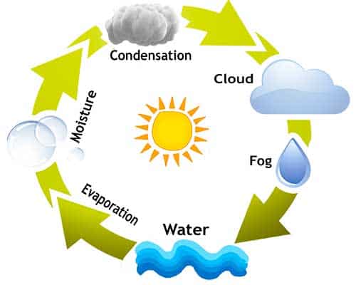
Fog formation explains: Moisture happens when water evaporates into the air, allowing for saturation near the surface. As the water evaporates, it warms the air layer closest to the ground, allowing for sharp contrast and temperature. As the moisture rises, the water turns into vapor. It looks like steam and fog.
Have you ever noticed that fog can develop even after rain moves out? That’s because a warm layer of air can move in that warms your raindrop as it’s raining. But then, eventually, it cools as it gets closer to the surface and moves through the cooler air. Also, evaporation starts a little sooner than in other circumstances. It creates an area of moist air closer to the ground, saturated, and the water turns into vapor.
Why do you see fog in the mountainous area? It happens when cold air in the lower elevations and the valleys begin to ride up the mountain’s slope. As this occurs, the air turns colder and eventually gets a thin layer of moisture to develop on that slope. It rises, and that will convert into water vapor and mist.
Radiation fog is the most common type during autumn mornings. Clear skies and crisp temperatures aid it. The cooling-off of land overnight is called thermal radiation. Also, It drops the temperature at the surface to the dew point temperature, allowing condensation and fog. Radiation fog usually dissipates soon after sunrise as the ground quickly warms up.
Where does the fog come from? The sky is clear in the mornings, and the temperatures are crisp. During the evenings, the air cools, loses its ability to hold water vapor, and then condenses, creating tiny liquid water droplets that hang in the air. After this occurs, fog appears. However, this fog doesn’t last long once the Sun rises in the morning. The fog begins to burn off, and it then can appear as a low-lying cloud.
Different Types Of Fog
There are different kinds of fog. It depends on temperature, air pressure, and the atmosphere. Now, we will learn about different types of fog and their formation.
Radiation fog: The most common type of fog is radiation fog. It forms on clear nights with light winds. As the ground radiates heat away toward space, it absorbs heat from the air. This process cools the air throughout the night.
If the air temperature drops to the dew point, the water vapor condenses to form a cloud above the ground. If there is a slight breeze, the water vapor will spread vertically. However, the fog becomes invisible if the wind is too strong.
Advection fog forms when warm, humid air blows in or adds vets over a cool surface. The ground absorbs heat from that air, lowering its temperature to the dew point. It is extremely common in areas with cold ocean currents, such as California’s Bay Area.
Precipitation fog: Precipitation fog is another fog that forms when air falls or precipitation falls into cooler air. Precipitation or frontal fog occurs when light rain or drizzle evaporates into relatively dry air long before reaching the ground. This both cools the air and adds more moisture. A temperature and dew point get closer and closer together until fog forms.
This fog forms by evaporation. So, the dew point goes up to meet the temperature. What happens as precipitation falls into colder air? As precipitation falls, it evaporates, evaporation increases the air’s water vapor content. As the water vapor content increases, it’ll finally reach saturation and produce a lower layer of fog. So, the air can reach saturation and reduce visibility significantly in that area of precipitation.
Upslope fog: Upslope fog clings to the sides of hills and mountains as humid air blows up their slopes. In this case, like the previous cases, the temperature drops down to meet the dew point. Upslope fog results from adiabatic cooling as air rises. It expands in a cool through-force descent.
Steam fog: Steam fog forms as cool air blows over warm water. The opposite of advection fog is steam fog. Warm waters are associated with warm, moist air. When a mass of cold air moves in, it cools the warm air’s moisture into a liquid. Usually, this type of fog does not get very high. Since cold air is required, it usually happens near the Arctic and Antarctica.
Freezing fog: There’s even freezing fog where supercooled water droplets from the fog at sub-zero temperatures then freeze into ice when they contact a surface.
Ice fog: The fog droplets freeze into ice crystals in the air. Ice fog can form either cooling the air to saturation. It disappears pretty quickly. But when you reach temperatures minus 40 Celcius or colder, the ice fog sticks around and doesn’t burn off as quickly.
What’s the foggiest place on earth? The Grand Banks off the east coast of Newfoundland, where the cold Labrador Current meets the warm Gulf Stream. This mixture provides the perfect environment for the fog to form.
The formation of morning fog is influenced by various factors, including the local geography, the difference between air and dew point temperatures, the presence of water bodies, and the overall weather conditions.
From tiny water droplets to the conditions that bring them together, we’ve explored the science that paints our world with this natural, misty brush. We hope you’ve enjoyed this journey as much as we did and that you’ll look at foggy days with even more wonder and appreciation.
So, the next time you find yourself enveloped in a blanket of fog, remember the delicate dance of nature that makes it all possible. Thanks for joining us in peeling back the veil on this atmospheric marvel. Until our next adventure, keep exploring the wonders around you and never stop being curious about the natural magic that surrounds us every day. Happy mist-eries!
More Articles:
Why Are Clouds White? – Dark & White Cloud Explanation
How Do Clouds Float? – Floating Clouds Explanation
How Is Rain Formed? – Water Cycle, Cloud & Rainfall Types
What Is Rain Shadow Effect? – By Mountain Diagram
How Does A Thunderstorm Form? – Types, Structure & Facts
References:
Gultepe, Ismail, ed. “Fog Visibility and Forecasting.” Fog and Boundary Layer Clouds.
“Federal Meteorological Handbook Number 1: Chapter 8 – Present Weather”. Office of the Federal Coordinator for Meteorology.
Robert Penrose Pearce. Meteorology at the Millennium. Academic Press.
“Virga and Dry Thunderstorms.” National Weather Service Office, Spokane, Washington.