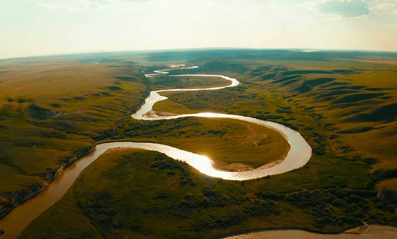
Rivers that gently flow over sloping ground begin to curve back and forth. These bending, looping rivers are called meandering rivers. So what causes a river to bend in the first place? All it takes is a little disturbance and a lot of time, which is plenty in nature. River bends are asymmetric due to obstructions. Hence, the speed of flowing water between the banks differs.
Meanders are a feature of old age. As rivers age, they develop more and more exaggerated meanders. Eventually, the meander becomes so exaggerated that the curve is abandoned, forming an oxbow lake. The channel becomes straight again. Humans can only develop these curves when an area is flat, like back east at the Mississippi. The exaggerated curves also mean central Washington used to be flat. But there’s a twist. This place isn’t flat anymore. This is a deep canyon system.
Why do rivers meander?
Rivers meander due to a combination of factors, including the flow of water, the characteristics of the river channel, and the erodibility of the surrounding land. Here are the main reasons why rivers meander:
Lateral Erosion: Rivers naturally erode the banks of their channels over time. The force of the flowing water is typically stronger on the outer bank of a curve, where the water flows faster due to centrifugal force. This differential flow causes more erosion on the outer bank while the inner bank experiences sediment deposition. As a result, the river gradually shifts its course towards the outer bank, creating a meander bend.
Erodible Banks: The erodibility of the river banks plays a role in meander formation. If the banks are composed of softer, more easily erodible materials, such as clay or loose sediment, they are more prone to erosion. In contrast, harder materials like bedrock or consolidated soil are more erosion-resistant, resulting in a more stable river channel.
Sediment Transport: Rivers carry sediments, such as sand, silt, and gravel, as they flow. This sediment can act as an abrasive agent, further contributing to bank erosion. As the river erodes the outer bank, it picks up sediment and transports it downstream. This sediment can then be deposited on the inner bank of the meander bends or downstream, contributing to the formation and growth of point bars and floodplains.
Flow Variations: The river’s water flow is not constant but can vary depending on factors such as seasonal changes in precipitation or runoff from tributaries. During high-flow periods, the river may have more energy and rapidly erode the banks. This can increase meandering as the channel adjusts to the changing flow conditions.
Channel Resistance: The resistance offered by the river channel itself can also influence meandering. If the channel has rough surfaces or obstacles, such as large rocks or fallen trees, it can impede the flow of water, causing the river to seek an easier path. This can result in meander bends as the river diverts around obstacles.
Meander is a slight bend in the river, and water will continue to flow down the river’s long profile from the upper course to the low cost. As the water flows through the meander, it travels faster on the outside bend creating erosion through abrasion and hydraulic action. It undercuts the riverbank and forms a river cliff, whereas the water travels slower on the inside bend, causing deposition to create a slip-off slope.
The meanders got established when the area was flat. A subtle curve is becoming a more exaggerated curve. Entrenched meanders tell that the land is lifting against the river. The river has been down there for millions of years. The land has been lifting against the meander against the river. The river’s been cutting, matching an uplift rate of the bedrock—basalt layer after basalt layer exposing themselves on the way up.
The winding curve in a river results from erosional and depositional processes. River water flows around various obstructions, such as stones and rocks, which results in different areas of slow and fast-moving water. Deeper parts of the river contain slower water areas filled with fine sediments. These parts are known as pools. Shallower parts of the river have faster areas of water and larger stones.
These areas are called riffles. The river now swings side to side, and the pools move to opposite sides of the relatively straight channel over time. As fast-flowing water erodes the outside of the pool and slow-flowing water deposits, various materials inside the pool meander begin to occur.
Meanders are formed in the middle course of a river. The rivers flow through almost a flat plane in the middle courses. A winding course develops as water flowing under gravity seldom flows straight for long distances. The irregularities of the ground force the river to swing in great S-shaped curves forming horseshoe-like loops called meanders.
The course of a river comprises three distinct paths.
- First is the upper or the mountain course where the river originates. Here the velocity of the water is faster due to the steep gradient. The floor of the valley is narrow, and the valleys are reshaped.
- The second is the middle of the valley course, where floors are wider, and the sides of the valley are more gently sloping. Here the velocity of the river is slower than in the upper stage. Meanders are typical landforms found in this stage of the river.
- The third part of the river is on the lower course with a gentle slope and is almost flat. The river channel is usually at its widest and deepest here. It is because the amount of water flowing within the river is at its greatest. Oxbow lakes are conspicuous features in the lower course of a river apart from the deltas, where the river
drains inter seas.
The water in a river channel flows faster around the outside bend due to centrifugal force, whereas it is relatively slow on the inside bends. The fast-flowing water on the outside bend erodes the riverbanks, whereas slow-moving water deposits sand and mud on the inside bend. A steep river cliff is created at the erosion site on the outside bend. The water piles up on the outside bend due to centrifugal force. A bottom current is set up in a corkscrew motion that deposits the eroded material on the inner bank, forming a slope slip.
A meander becomes very much pronounced in the lower course of a river. The outside bend erodes rapidly, and the meander loop becomes a complete circle. Gradually the narrow necks of the loop erode further and intersect each other. Now the river cuts through the intersection to flow in a straight path. As a result, the meander loop is abandoned, forming an oxbow lake. The oxbow lake becomes a swamp, and subsequent floods may silt up the lake. It becomes marshy and eventually dries up.
On the faster side of the river, speedy water carries loose dirt and rocks from the riverbed and banks eroding to form a hollow. Water gushes into the newly formed hollow with increased speed and erodes more. The water runs faster through the new opening and does the opposite bank. On the slower-moving side, water can’t carry much weight.
Hence, all the dirt moves to the bottom, making the river shallower until it becomes land. While one side of the river is drying up, the new curve causes water running against the outside bank to pick up enough force. It slams into the opposite bank further down the river. It also creates another curve, then another, until eventually, a windy, snakelike river.
The meanders tend to grow with time. That’s because water enters a bend and flows inside the bend. It tends to be much slower than the flow on the outside. Imagine the water coming through the outside has to swing around much more quickly than inside. So that is the general relationship about the Reynolds number, which depends on flow speed.
Scientists can’t predict because the bend tends to grow and become larger and larger. The outside of the bend is eroding, and the inside is depositing. The Reynolds number depends both on flow speed and water depth. The highest water depth and the fastest flow speeds outside the bend carry the highest Reynolds number.
More Articles:
How Do Ocean Currents Affect On Climate Change?
Why Do Rivers Flow In One Direction?
Why Do Most Rivers Flow North To South?
References:
Rosenberg, Matt, “Do All Rivers Flow South?”.
Rosenberg, Matt. “Rivers Flowing North: Rivers Only Flow Downhill; Rivers Do Not Prefer to Flow South.”
Rydell, Nezette, “Re: What determines the direction of river flow? Elevation, Topography, Gravity??”. Earth Sciences.