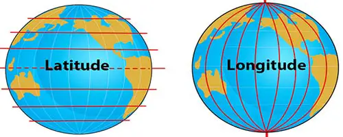
Geographic coordinates have latitude and longitude. Latitude represents the north-south location, and longitude represents the east-west location. Combining them allows you to pinpoint any spot on the Earth’s surface. These coordinates aren’t expressed in units of distance but in degrees. That is because the Earth is a sphere.
The Air Force created the first generation of the Global Positioning System in 1973 for finding lost soldiers. GPS isn’t only for positioning anymore but also for timekeeping situations where everything needs to be synchronized perfectly.
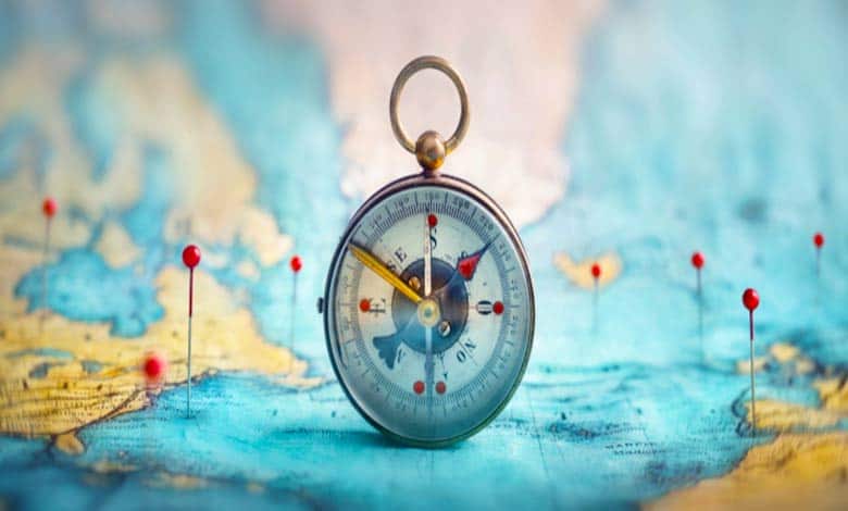
How do GPS coordinates work? (Map Location Identify)
GPS coordinates work by leveraging signals from satellites to determine an exact position. Here’s a breakdown of how GPS coordinates function:
Satellite Network: GPS relies on a constellation of satellites orbiting the Earth. These satellites continuously transmit signals containing precise timing information and location data.
Trilateration: To determine a position on Earth, a GPS receiver must receive signals from at least four GPS satellites simultaneously. The receiver measures the time it takes for the signals to reach it from each satellite.
Time Delay Calculation: The GPS receiver calculates the distance to each satellite by multiplying the time delay of the signal by the speed of light. As the signal travels at a known speed, the receiver can determine the distance based on the time it takes to arrive.
Position Calculation: The GPS receiver performs trilateration using the distances calculated from the satellites. Trilateration involves intersecting the spheres around each satellite (with the receiver’s distance as the radius) to determine the receiver’s location. The intersection point of these spheres represents the receiver’s position.
Coordinate System: GPS coordinates use latitude, longitude, and sometimes altitude to define a specific location on Earth’s surface. Latitude measures the distance north or south of the equator, longitude measures the distance east or west of a prime meridian (usually the Greenwich Meridian), and altitude measures the vertical distance above or below a reference point, such as sea level.
Coordinate Format: GPS coordinates are typically expressed in degrees, minutes, and seconds (DMS) or decimal degrees (DD) format. DMS format represents coordinates as degrees (°), minutes (‘), and seconds (“). Decimal degrees format represents coordinates as a decimal number, with positive or negative values indicating north or south latitude and east or west longitude.
The Earth is divided into horizontal lines of latitude and vertical lines of longitude. Latitude is read first, longitude second. Latitude lines are known as parallels that are read in terms of north and south of the equator. The starting point is the equator, which is zero degrees latitude.
Latitudes and longitudes are invisible lines that help us identify a place using geometrical coordinates. An easy way to remember the orientation is that latitudes are lateral and longitudes are long.
Latitudes: Latitude lines circled the globe in the east-west direction. It measures how far north or south a specific point lies from the equator. They’re also known as parallels. The distance between each degree of latitude is approximately 69 miles.
Longitudes: Longitudinal lines run from the North Pole to the South Pole. It measures how far east or west a point lies from the prime meridian. These are also known as prime meridians. Longitudes can value from 0 degrees to 180 degrees east. The distance between longitudes at the equator is the same as latitude, roughly 69 miles. At 45 degrees south or north, the distance is about 49 miles.
- 90 degrees south of the Equator is the South Pole or southern hemisphere.
- The North Pole or northern hemisphere is 90 degrees latitude north of the Equator.
- West of the Prime Meridian is the Western Hemisphere.
- East of the prime meridian is Eastern Hemisphere.
- South of the Equator is the Tropic Capricorn ( 23°26′11.9″ S).
- North of the Equator (23°26′11.9″ N) is the Tropic of Cancer.
- The Arctic and Antarctic circles are at 66 degrees 33 minutes 44 seconds north and south of the Equator.
- The starting point for reading longitude is the Prime Meridian. It is a line passing near the Royal Observatory in Greenwich near London in the United Kingdom.
To locate a precise point on the Earth’s surface, degrees of latitude and longitude have been divided into minutes and seconds. There are 60 minutes in each degree, and each minute is divided into 60 seconds.
For example, the Great Pyramid of Giza coordinates 29 degrees 58 minutes 45.03 seconds north, 31 degrees 08 minutes, and 03.69 seconds east.
Imagine a line running from the equator to the center of the Earth. Then another line runs from the Earth’s center to the north or south pole. These two lines make a 90-degree angle. All latitudes in each hemisphere can be represented by drawing the third line between them. So the equator would have 0 degrees latitude, and the north pole would have 90 degrees north latitude. And a location halfway between the north pole and the equator would lie 45 degrees north.
The same thing for the southern hemisphere, except you call it degrees south. For more precision, each degree of the Earth’s surface is divided evenly into 60 “minutes,” and each minute is divided into 60 “seconds.”
- For more specifics, add decimals to seconds. Alternately, write the whole coordinate in decimal notation.
Learn about GPS coordinates
To do this, you must convert minutes and seconds, base-60, into our regular base-10 counting system by dividing each unit by sixty and then summing them up. The results sometimes look counterintuitive.
Lines of longitude, called meridians, run north-south and measure position along the east-west axis. While the lines of latitude run parallel, meridians converge at the poles and spread farthest apart at the equator, like the segments of an orange.
Longitude is also measured in degrees, but its zero-degree line is known as the Prime Meridian, and it runs from the North Pole to the South Pole through Greenwich, England.
- If the Prime Meridian is zero degrees, the opposite side of the Earth is 180 degrees, and lines in between are expressed as degrees east or west, between 0 and 180.
Since the lines of latitude are parallel, each degree covers about the same distance of the world, over roughly 111 kilometers. As meridians converge at the poles, the distance covered in each degree of longitude varies hugely depending on latitude.
- At 20 degrees North, about the latitude of Cuba and Hawaii, one degree of longitude is approximately 104 kilometers.
- At 80 degrees North, the latitude of Svalbard and northern Greenland, it’s only about 19 kilometers.
Even without looking at a map, we can start to guess where this would be. Since it’s 43 degrees north, it’s almost halfway between the equator and the north pole again, halfway being 45 degrees. Since it’s 89 degrees west, it’s almost halfway west between the prime meridian and the opposite side of the globe, halfway being half of 180 degrees or 90 degrees. On Google Earth, these coordinates point to the U.S. National Mustard Museum in Middleton, Wisconsin.
More Articles:
Why Does Earth Have Many Deserts?